
2022 Nebraska/Dakotas Chapter Annual Award Winners
Congratulations to our 2022 Annual Award Winners!
AWARDS OF EXCELLENCE
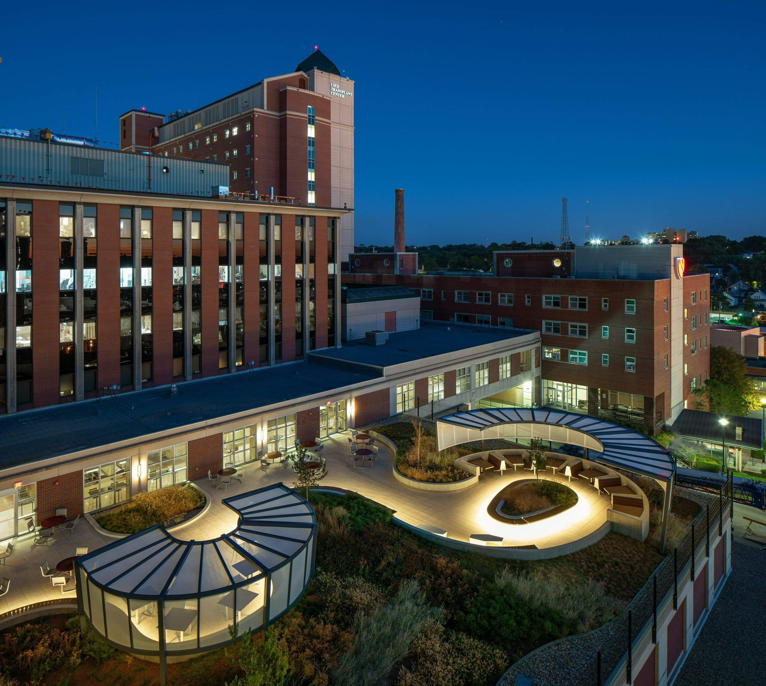
Project: Nebraska Medicine - Durham Outpatient Center Rooftop Plaza
Category: Design (Built)
Location: Omaha, NE
Firm: RDG Planning and Design
Outside of the Nebraska Café on level three of Nebraska Medicine’s University Tower, the Rooftop Plaza had fallen into disrepair. Initially built in the early nineties, the space had closed for use due to a lack of shade opportunities, uneven pedestal paving, plugged drains, and the roof membrane needing replacement. Nebraska Medicine recognized this project as an opportunity for staff, patients, and visitors to interact with the outdoor environment, demonstrate sustainable practices, and provide an engaging, artful plaza space.
The guiding principles of the project included:
Providing shaded, protected areas from University Tower’s southwestern exposure.
Creating layers of intimate spaces that focus inward while still maintaining visibility.
Incorporating a variety of seating types. Serving as an extension of the Nebraska Café eating area.
Updating the perimeter fencing and factoring safety into the design, keeping users away from the building edge.
Planting for color and variation that can be enjoyed throughout the seasons.
The new plaza design functions as an intensive green roof, creating opportunities for a biodiverse demonstration of prairie environments. Further benefits include reducing overall stormwater runoff and noise, improving stormwater and air quality, urban heat island mitigation, and year-round aesthetic interest for users of the Nebraska Café.
The incorporation of ornamental trees was achieved by coordinating their location with the building’s columns and utilizing tapered board insulation to create planting pits that were the proper depth. In contrast, the surrounding landscape’s soil media depth and plant selection were selectively chosen for individual plant health success and to lessen the weight of the raised plantings on the building structure.
The improvements to this space will also hold research-backed wellness advantages, such as stress reduction and lessened perceived discomfort, thus reducing healing times. The variety of outdoor seating options offers users the autonomy of choice in finding a space that meets their desired needs, hopefully encouraging increased usage and engagement with nature within the hospital campus.
Click here to see more of the project.
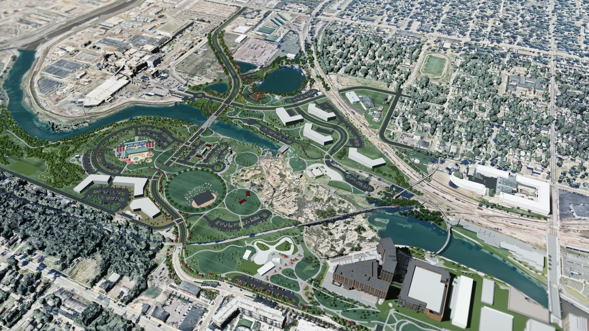
Project: Falls Park Master Plan
Category: Design (Unbuilt)
Location: Sioux Falls, SD
Firm: Confluence
Falls Park is a large, 120-acre, municipal park located in downtown Sioux Falls, SD. Falls Park is named after the raging waters of the Big Sioux River that tumbles over the exposed quartzite bedrock located within the park. This natural wonder makes the park a destination point for area residents and tourists year-round. In the early 2000’s, the City of Sioux Falls began a series of significant investments to revitalize its downtown and clean-up of Falls Park. This entailed demolition and remediation of unused industrial sites, street and utility projects throughout the central business district, improvements to the City’s downtown river greenway, and multiple streetscape improvements within the City’s downtown core.
A resounding theme emerged during our engagement with the Sioux Falls community: “Please DON’T significantly change the heart of the park – but improve the overall experience and connectivity with the surrounding area.”
Four key themes were part of the planning process:
Provide engaging multi-functional spaces within the park.
Provide equitable access to Falls Park from adjacent neighborhoods.
Listen to the community.
Introduce diverse revenue streams to support park operations.
The master plan investigates landscapes that are accessible and respond to the changing seasons with a focus on more year-round programming. Recommendations include new and compelling experiences to support a wide range of social and physical activities. The design builds upon the existing features and spaces of the park and surrounding community while incorporating new and innovative amenities, creates opportunities for economic development, and enhances the potential for long-term viability and sustainability of park operations, programs and maintenance.
Prioritizing Access and Connectivity to the site led to the transformation of existing entry experiences and site circulation - including both vehicular and pedestrian. These new entry experiences create dynamic viewsheds to park facilities while reducing pedestrian and vehicle conflicts, providing more direct connections to the local neighborhoods. These connections will eliminate unsafe intersections, provide safe railway crossings, and improve pedestrian and bicycle access. Redevelopment of the park edges through land swaps and the realignment of city street connections will help also fund major infrastructure changes and activate the park with adjacent new residences and businesses.
The Landscape Architect also unified park land through creative roadway realignments, the introduction of land bridges, the use of shared parking between park destinations, and prioritizing pedestrian/bicycle movements over vehicular traffic to creating a safer and more connected park trail system. Areas that were previously disconnected from the park by existing rail lines were reconnected through new roadway tunnels and pedestrian bridges spanning the rails and the river to directly connect adjacent residents with the heart of the park.
These larger planning and development moves modified the existing edges and boundaries of the park, blurring the lines between public and private properties to better integrate new mixed-use development and housing while also addressing park equity and accessibility.
To see more of the master plan, click here.
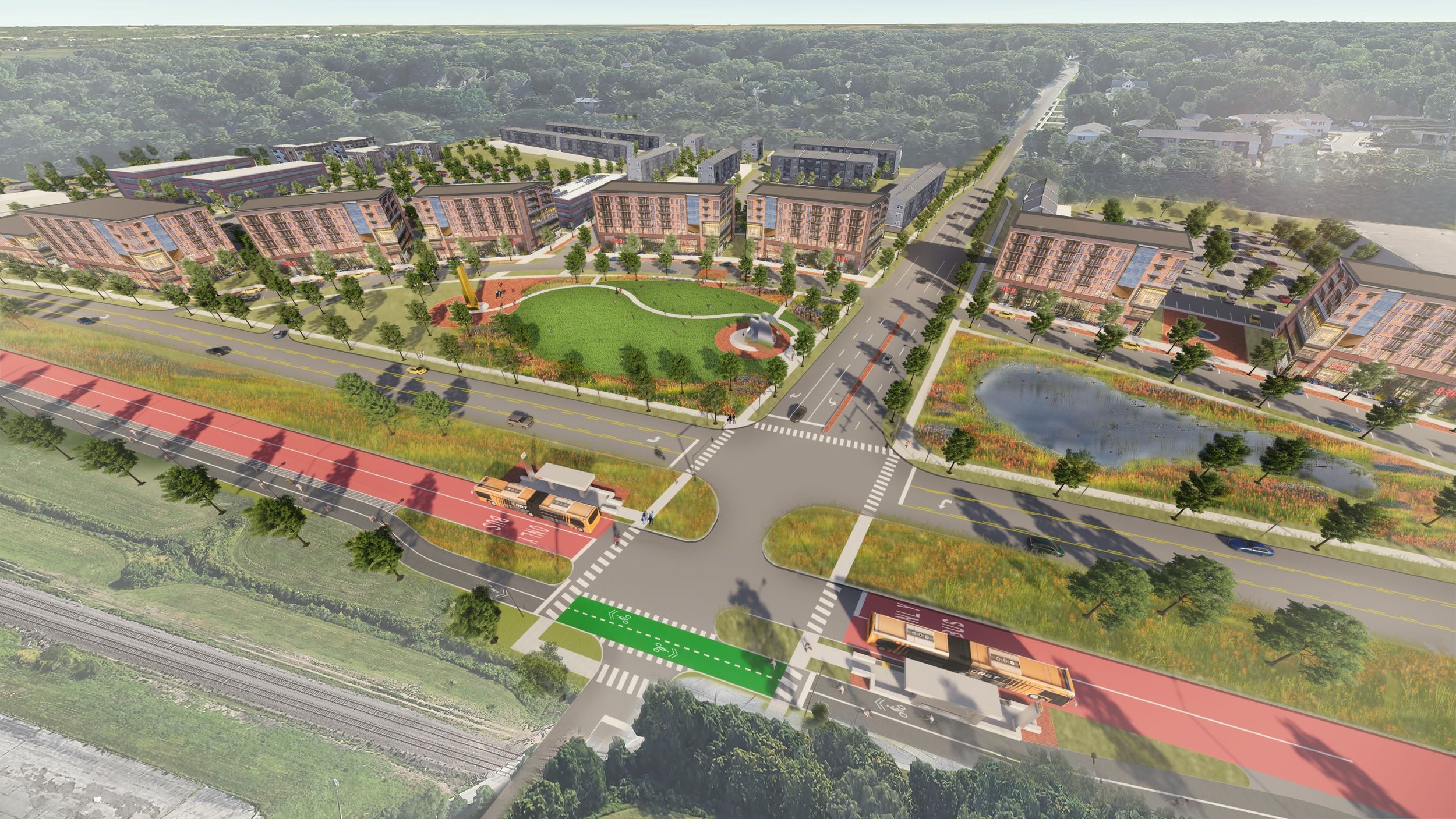
Project: Fort Crook Road 2040
Category: Planning & Analysis
Location: Bellevue, NE
Firm: HDR
The Fort Crook Road 2040 plan envisions the corridor transformed into a multi-modal conduit that will attract new residents, businesses, and visitors to the heart of Bellevue. The plan reconfigures the existing street section to include a bi-directional exclusive transitway and a bi-directional protected bikeway. This total mobility sytem is then complemented by transit-oriented development and green infrastructure throughout the corridor. As planned, new neighborhoods will foster an attractive, walkable urban lifestyle that is directly connected to Downtown Omaha, Midtown Crossing, the Blackstone neighborhood, and UNMC via the 24th Street BRT line, placing the corridor at a significant competitive advantage for redevelopment within the metro area.
Bellevue is quickly approaching a point where land available for new “greenfield” development within its jurisdiction will no longer exist. At present rates of devlopment and looking ahead across various market factors, it is anticipated that the available land within the ETJ will be exhausted within the next 35 years. When this occurs, the city will face the same challenges as communities like Detroit, St. Louis, and Des Moines. With no outlet for continued growth, the population will stagnate, tax revenues will remain flat, and services will suffer. It will be difficult to maintain the existing quality of life the city’s residents currently enjoy.
To avoid negative consequences of curtailed growth opportunities, Bellevue must proactively position itself for success, and embrace infill redevelopment and density at its core. The Fort Crook Road corridor has the existing capacity to support this type of growth.
To achieve the vision of a walkable urban lifestyle, the corridor must embrace its opportunities, challenges, and potential:
It must capitalize on the proposed Metro BRT (Bus Rapid Transit) line that will run on South 24th Street to Dodge Street to Q street/the South Omaha Transit Center.
It must extend this line along Fort Crook Road and use the corridor’s excess lane capacity as an exclusive transitway and protected bikeway.
It must strategically place BRT stations along the corridor so they can be used as catalysts for reinvestment/redevelopment.
It must turn the corridor’s wetlands into neighborhood assets. Floodplain concerns will need to be addressed prior to final implementation.
It must require all new development projects along the corridor to use Transit Oriented Development (TOD) design principles that encourage ridership.
To see more of the master plan, click here.
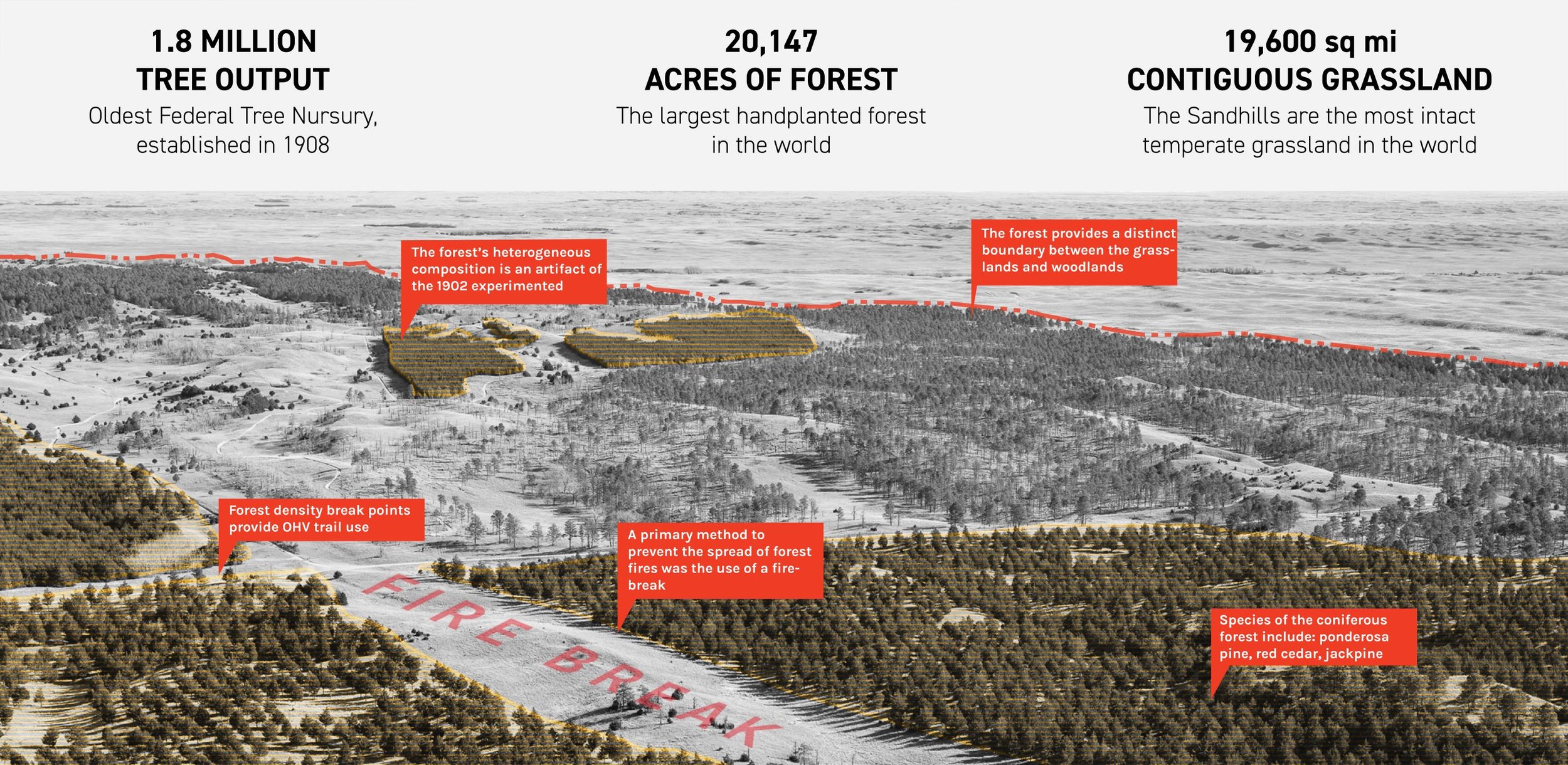
Project: Trail Guide for a Hybrid Landscape
Category: Planning & Analysis (Student Category)
Location: Nebraska National Forest: Bessey Ranger District, NE
Student: Sean Kelly, University of Nebraska - Lincoln
The Nebraska National Forest - Bessey Ranger District is home to one of the most geographically unique landscapes in the world. Beginning as an experiment in 1902 with Dr. Charles E. Bessey, professor at the University of Nebraska - Lincoln, he hoped to populate a region of the Nebraska Sandhills with dense coniferous forest in order to provide timber production for the region. With the help of Forest Service Chief Gifford Pinchot and President Theodore Roosevelt, the experiment became a landmark in the history of the Great Plains and the National Forest Service. The forest at the Bessey Ranger District was at one point the largest hand planted forest in the world, with a planted area spanning 20,000 acres across the Nebraska Sandhills. The Nebraska Sandhills are the most intact contiguous grass-stabilized sand dune ecosystem globally. This extraordinary forest gives rise to opportunities regarding its position within the Sandhills and the cultural and ecological implications it poses within the region. By examining this “hybrid landscape” through cultural and environmental perspectives, the proposed trail system unearths latent narratives that situate the forest as an icon of ecological experimentation through in-depth research and mapping, culminating in the development of a trail system that interprets the entangled narratives of the forest for those who come to experience it.
In its current state, the Bessey Ranger District lacks a sophisticated trail infrastructure. In collaboration with the Forest Service employees at the Bessey Ranger District, this project proposed six new trail alignments for the forest: The Bessey Archery Range, The Tree Line, The Fire Tower trail, The Windmill trails, The Nursery Loop, and The Middle Loup Water trail. Each trail has its own unique characteristics, including aspects related to its difficulty or particular use. Each trail navigates its way through the entangled forest and grassland in an attempt to introduce visitors to the concept of the hybrid landscape. The elements of each trail vary from focusing on aspects such as accessibility, exercise, education, and different forms of transportation. The landscape itself presented challenges to every trail alignment, including the steep grades of the undulating hills and the loose sandy ground condition. The trail system uses the unique landscape, from its strenuous topography and dramatic juxtaposition of the forest and grasslands to its advantage, including the ability to frame certain views into the forest or expose the vastness of the sandhills from the forest edge. The trails traverse the boundaries of the plantation to find ways to engage with the first federally operated nursery, into the pastures of the sandhills, and along the Ogallala aquifer-fed dismal river. The trail alignments themselves are tools to reveal the entangled narratives of the forest through curated moments of interpretation.
The Middle Loup Water trail explores elements of aquatic resources and conservation while allowing access to these areas so users can have a more integrated experience with these different environments. Related to the ideas of habitat and species conservation, The Bessey Archery Range provides far more opportunities for exploration and enlightenment than a typical archery range through the experience along the trail itself and the inclusion of the canopy walk education area. Interpretive moments of sculpture and play represent the efforts and results of the conservation of native fauna and habitat through funding from the purchase of hunting permits. The history of bow hunting dating back to the Native Americans that once hunted this region is explored through interpretive signage elements, which connects current archers to the fascinating past of this humble tool. The messages of Native American history and its impact on this region are carried through other trails, including The Tree Line. The entangled narratives that are uncovered relate directly to the main idea behind the definition of hybrid, the tame and the wild. The ideas of native and non-native relate to the hybrid concept, including the colonization of Native American lands. This trail also explores the condition of the seemingly wild nature of the dense forest adjacent to the tameness of the grassland. The impacts of wildfires compared to controlled burns are explored within the ideas of forest and prairie management along The Tree Line through interpretive signage along the boardwalk that rides the juxtaposition of the forest against the openness of the firebreak. The fundamentals of land management through fire are also explored through interpretive signage located along The Fire Tower Trail, which passes by the iconic Scott Lookout Tower. The metal-framed edifice that rises above the treeline was the inspiration for the structure of the signage utilized within the design. The idea of grazing situates itself into the hybrid concept as it relates to the historical impacts of wild buffalo compared to the new control methods of grazing with tamed livestock, the concepts of which can be explored on The Tree Line as well along The Windmill Trail. This trail takes horseback riders through grazing lands within the National Forest boundaries and challenges them to locate the different windmills near the trails, which are an iconic sight and an important piece of equipment that extract groundwater for livestock to drink. Shifting away from livestock production through grazing, the Nursery Trail takes users around the Nursery and exposes them to the ideas of afforestation and reforestation.
To see more of the trail guide, click here.
HONOR AWARDS
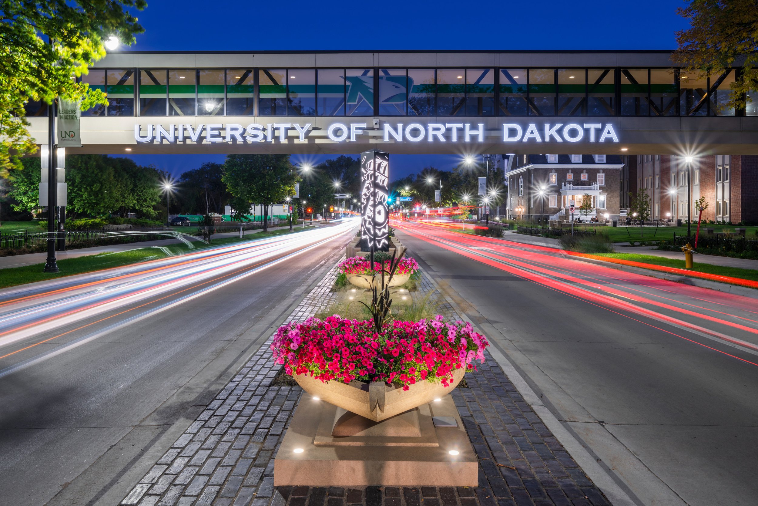
Project: University Avenue Streetscape
Category: Design (Built)
Location: Grand Forks, ND
Firm: RDG Planning and Design
The transformed “Main Street” for the University of North Dakota features a family of bespoke designs for fencing, median planter walls, planter urns, architectural monuments, arched benches, light monument bases and monumental signage – together improving safety and celebrating this vibrant campus as a complete street, year-round.
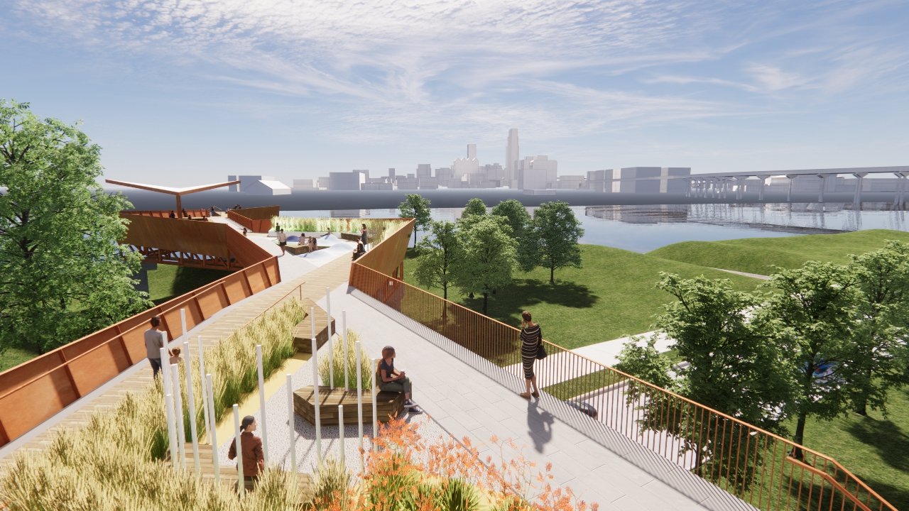
Project: SINC South Pier
Category: Design (Unbuilt)
Location: Council Bluffs, IA
Firm: HDR
The Charles E. Lakin Foundation Pier is built upon an expressive experience that resonates with its setting and the natural environment along the Missouri River. The meandering and intersecting paths recall the braids of the river. The pier will support play and educational interaction and inspire inquisitiveness among its visitors.
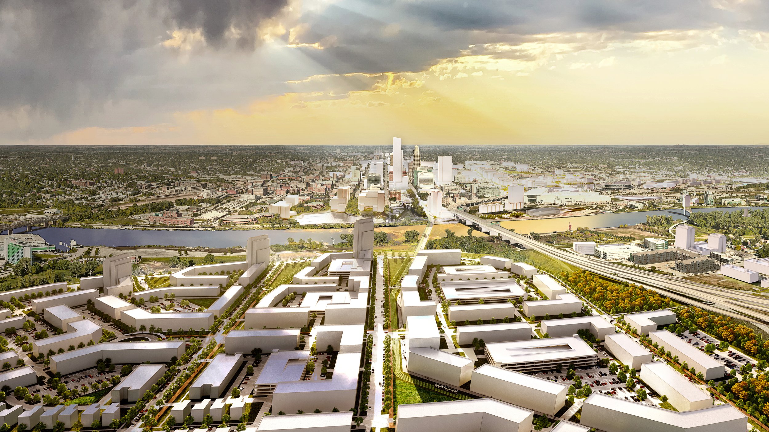
Project: Urban Core Strategic Plan
Category: Planning & Analysis
Location: Omana, NE & Council Bluffs, IA
Firm: HDR
The Urban Core Strategic Plan was developed to capture a vision for the transformation of the heart of the Omaha metropolitan area. The major initiatives and sub-area concepts proposed can help achieve the “30-30-20” goal, attract visitors and a talented workforce, and enhance the quality of life for all.
MERIT AWARD
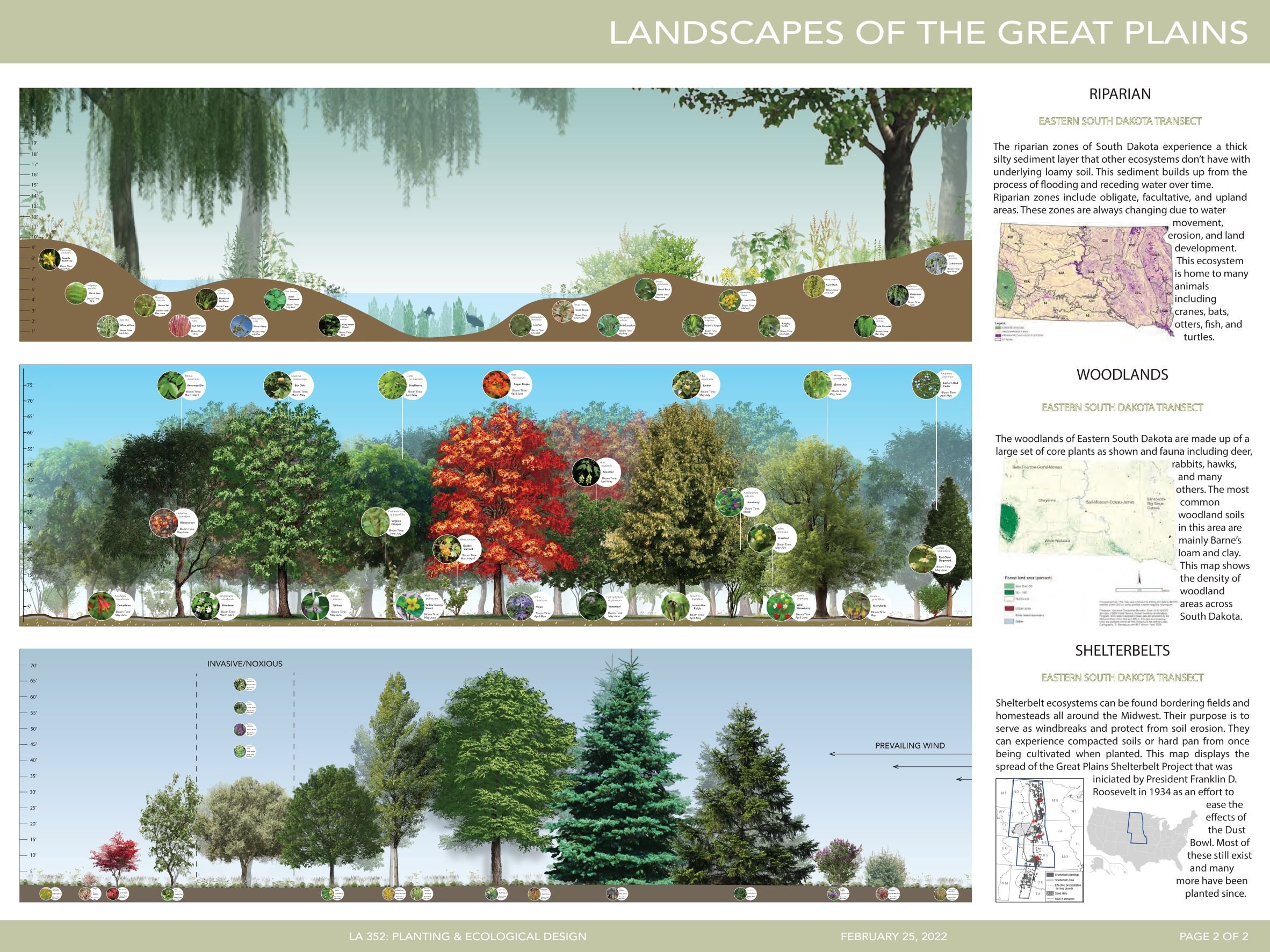
Project: Plant Communities of the Great Plains Study
Category: Planning & Analysis (Student Category)
Location: Brookings, SD
Student: Janie Vandal, South Dakota State University
This project illustrates data and graphics developed through research done for Eastern South Dakota and the Great Plains region. Information was collected on native plant species within dominant plant communities and the digital illustrations created to represent each ecosystem with their most common plants and animals.
